Tuesday, July 5, 2011

BIAFO GLACIER (3rd Largest Glacier of the world)


The Biafo Glacier is located in Pakistan in the Karakoram Mountains of the Northern Areas. The Biafo Glacier is the world's third longest glacier outside of the Polar Regions (Arctic and Antarctica). It is 63 km long glacier.


Biafo Glacier is place in remote and isolated area. It is located in Baltistan –Gilgit region of Pakistan This region boast number of mountains peaks and huge glaciers. Biafo Glacier meets Hispar Glacier at an altitude of 5,128 m (16,824 feet) at Hispar La (Pass). Hispar Glacier is 49 km long. The traverse uses 51 of the Biafo Glacier's 63 km and 49 km of the Hispar Glacier to form a 100 km glacial route. This highway of ice connects two ancient mountain kingdoms, Nagar, immediately south of Hunza in the west with Baltistan in the east. Biafo Glacier is towards the northwest of the Baltoro Glacier.


At the base of Hispar Pass on its eastern edge lies Snow Lake. It is a basin of ice located 16,000 feet (4,877 m) above sea level and is approximately 10 miles (16 km) wide surrounded by granite pinnacles. The ice is found to be approximately 1.6 km. deep. Some go as far as to say that Snow Lake represents the last of the original ice cap in the earth's temperate zones. Snow Lake basin lies at the head of the Biafo and Hispar glaciers, which spread down from the Hispar Pass in opposite directions, forming a 61 mile (100 km) river of ice that is among the world's longest continuous glacier systems outside the polar region (Arctic and Antarctica). Snow Lake, consisting of parts of the upper Biafo Glacier and its tributary glacier Sim Gang, is one of the world's largest basins of snow or ice in the world outside of the polar. Snow Lake is very difficult to reach. One has to travel a miles of glacier without setting a foot on earth. The trek is covered in ten to fifteen days. But Snow Lake is a magical place. It presents a stunning site, a site that is out of the world. On one hand there is the might and majesty of numerous peaks and on the other hand the huge snow covered white land. The view of stars in the sky at night is amazing. It can be an unforgettable experience for those who love nature and unique beauty.


The Biafo Glacier presents a trekker with several days of very strenuous and often frenzied boulder leaping. The trek is on rocks and snow most of the time. It contains crevasses. The trek is full of spectacular and continuously incredible views throughout. The hike takes through glistening clear lakes, bright spots of green grass, glorious wild flowers and the ever present vertical snow covered peaks. The sidewalls vary from very steep to precipitous. The glacier has carved striations on the surrounding country rocks. Moving ice has formed depressions, which serve as basins for numerous glacial lakes.


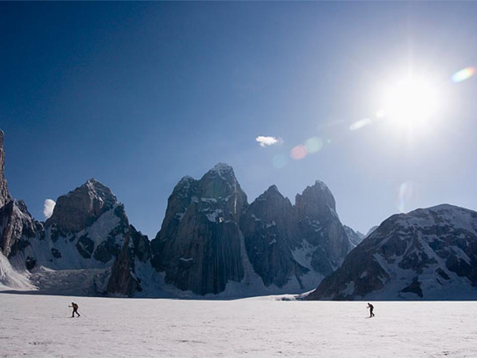
In Biafo Glacier the first sight is of the pinnacles of the Paiyu Group which is astonishing. The view of mountains is spectacular. It provides marvelous scenery. On one side the Biafo lies and on the other side the Hispar Glacier and the peaks above Hunza valley.


Campsites along the Biafo are located off of the glacier. It is adjacent to the side moraines and steep mountain sides. The three camp sites are MANGO, NAMLA & BAINTHA. Moving up from the last village Askole before the glacier are beautiful sites with flowing water nearby. Mango and Namla are the first two campsites, which are often covered in flowers. Namla has an amazing waterfall very close to the camping area. Baintha, the third camp site is often used as a rest day. There is a large green meadow near the camp and it has a few running streams and many places to spend the day rock climbing. Baintha Campsite is located on an ablation valley below the granite peaks of the Ogre (7813 m.).


Evidence of wildlife can be seen throughout the trek. The Ibex and the Markhor Mountain Goat are found and the area is famous for brown bears and snow leopards.  


The journey to Biafo Glacier begins in Skardu. From Skardu, a jeep may escort travellers through the Braldu Gorge to the thousand-year-old Askole village. The trek from Askole initially proceeds towards K2, then turns northwest up the Biafo Glacier to Snow Lake. The descent differs from the ascent Going is through the Hunza Valley and ending is in Gilgit.


On the route of Biafo Glacier one just come across the highest, the longest and the largest mountains, glacier and rivers of the world. The scenes are full of breathtaking splendor sights. The trek is like a paradise on the earth. It is paradise not only for mountaineers, trekkers and photographers, but for every nature lover.


Monday, June 27, 2011

Gasherbrum I (11th highest peak of the world)


Gasherbrum
I is the 11th highest peak of the world. It is located in Gilgit-Baltistan region of Pakistan. It lies on the Pakistan-China border. Gasherbrum I peak is also known as “Hidden Peak” or “K5”. It is Pakistan’s 3rd highest peak. It is at the elevation of 8,080 m (26,509 ft).It’s Prominence is 2,155 m (7,070 ft). It has coordinates : 35°43′28″N 76°41′47″E / 35.72444°N 76.69639°ECoordinates: 35°43′28″N 76°41′47″E / 35.72444°N 76.69639°E. Gasherbrum I is located in Karakoram range.


Gasherbrum is often claimed to mean "Shining Wall. It comes from "rgasha" (beautiful) + "brum" (mountain) in Balti which means "beautiful mountain." There are six Gasherbrum Peaks. The reference is may be due to the highly visible face of the neighboring peak Gasherbrum IV.


Gasherbrum I is listed in eight-thou sanders ultra. The eight-thou sanders are the fourteen independent mountains on Earth that are more than 8,000 metres (26,247 ft) high above sea level. They are all located in the Himalayan and Karakoram mountain ranges in Asia. Gasherbrum I is part of the Gasherbrum massif, located in the Karakoram region of the Himalaya. It is one of the four 8,000m peaks located in a tight cluster on the upper reaches of the Baltoro glacier, the main access route to the mountains which cuts through the center of the Karakoram. Of the world's fourteen highest mountains, four are located within the Karakoram Range: K2, Gasherbrum I and II, and Broad Peak. There are six Gasherbrum Peaks., namely Gasherbrum I, Gasherbrum II, Gasherbrum III, Gasherbrum IV, Gasherbrum V and Gasherbrum V.Gasherbrum is a remote group of high peaks in the Karakoram, located at the northeast end of the 36-mile Baltoro glacier.


Gasherbrum I was designated K5 (meaning the 5th peak of the Karakoram) by T.G. Montgomery in 1856. He sighted a group of high peaks in the Karakoram from more than 200 km away. He named five of these peaks K1, K2, K3, K4 and K5 where the K denotes Karakoram. Today, K1 is known as Masherbrum, K3 as Broad Peak, and K4 as Gasherbrum II and K5 as Gasherbrum I. Only K2, the second highest mountain in the world, has kept Montgomery’s name. William Martin Conway provided the alternate name, Hidden Peak, in reference to its extreme remoteness.

Gasherbrum I was first climbed on July 5, 1958 by an eight-man American expedition led by Nicholas B Clinch. Pete Schoening and Andy Kauffman.were first to reach the summit.


The peak was also the venue of the world’s first 8,000 meter climb in pure Alpine Style. This means that the start of the climb is done from the bottom of the mountain and all gears are carried on the way, if any bivouacs, they will be found on the way Reinhold Messner and Peter Habeler on 8 August 1975 summitted the peak and thus introduced pure Alpine style climbing to the Karokaram.

The most common way to climb the peak is to from the western side and all routes here leads to "The Japanese Couloir", which is located on top of the north-west face.

June to September is the normal climbing season. Gasherbrum I has never been climbed in the winter season due to  extreme cold, high avalanche risk, difficult logistics and deep snow.

Thursday, May 26, 2011

World’s largest fort (RaniKot fort) PAKISTAN-SINDH


RaniKot fort is world’s largest fort. Rani fort is situated in Sindh province of Pakistan. The fort is in Lakki Mountains of the Kirthar range at a distance of about 30 kilometers away from town of Sann. The way leads through Kotri and the town of Sann.  It is located approximately 270 km from Karachi and 90 km north of Hyderabad.


This magnificent and well-designed fort is symbol of best architecture a by gone era. It is reputed to be the largest unexplored fort in the world. Its walls are about 26 km or 16 miles in circumference. The walls of fort are made of gypsum and lime cut sandstone. Some walls are of crest stones Different types of bricks are used to build the wall which indicates its construction in different period of time. Its huge undulating walls weave and immerse over the hills are built with dressed sandstone and reinforced with 45 bastions along the outer wall, of which 7 are rectangular and the remaining are round.  Its wall is divided into two parts. First portion is 8.25 km long wall, which is man-made, built with yellow sandstone and 30 ft high. While other twenty six kilometers long wall is made of natural cliffs and mountains which at places rise as high as two thousand feet above sea level. A mountainous ridge, Karo Takkar (Black Hill), running north to south, forms its western boundary and the 'Lundi Hills' forms its eastern boundary.


The majestic fort is visible at glance from the distance.  Some of the walls bear a resemblance to the Great Wall of China as they weave through the hills. Therefore the fort’s wall is also called “The Great Wall of Sindh” and “Deware Sindh by locals.


Within Ranikot, there are two more fortresses; Meeri and Shergarh, each have five bastions. Meeri is small fortress. Meerikot have entrances, curved and angulated with a safe tortuous path. From the military point of view, Meerikot is located at a very safe and central place in the very heart of the Ranikot with residential arrangements including a water-well. The second fort looks like a giant eagle’s nest called Shergarh fort (house of lion) is roughly 15km. It can be seen from Meerikot. Shergarh is built with whitish stone, it too has five bastions. Though its location at 1480 feet above the sea level makes this fortress a unique structure, it also makes it equally hard for available of water, which can only be had from the brooks and rain streams, hundreds of feet below. The steep climb up to Shergarh gives a commanding view down over the whole fort and its entrance and exit points. On a clear day one can even see Indus, 37 kilometers away to the east.


A rain stream named “Mohan Nai” enters the fort from its rarely utilized western 'Mohan Gate'. It runs through it, fall downs in a series of turquoise pools to irrigate fields and leaves the fort from its most used 'Sann Gate' on the eastern side. It then floods about 33 kilometers more to enter the Indus River .A spring coming out from underground near the Mohan Gate is named as 'Parryen jo Tarr'  Another spring is Waggun jo Tarr or "the Crocodile Spring", named so as crocodiles were resided there.


The terrain inside the fort is plentiful with greenery, hills, valleys, streams, ditches, ponds, collections, fossils, building structure, bastions, watchtowers, ammunition depots, fortresses. The streams are abundant in tropical fish. Every structure in the Ranikot has its own uniqueness and beauty. Some of the area of the fort has been cultivated. Scattered animal skeletons and prehistoric fossils can be found on the top of Lundi Hills.  


The original aims and causes to build this marvel fort are unknown. There is no trace of any old city inside the fort and the present construction has little evidence of prehistoric origins. The present structure was reconstructed on the site of a much older fort by Mir Karam Ali Khan Talpur and his brother Mir Murad Ali in in the early 19th century, probably for the purpose to protect the trade route from Thatta through the Khirthar hills to Central Asia.


Beside the Mohan Gate and the Sann Gate, there are two more gates, rather counterfeit gates. One is towards the side of ancient town of Amri. This 'gate' is called the 'Amri Gate'.  There is a bridge over rain stream 'Toming Dhoro' exiting from the fort called 'Budhi Mori'. The breach in fort wall due to the river stream has been referred as a gate. Similarly, the Shahpir Gate to the south also appears to be a pseudo gate taking its name from a limestone rock with a rough shape of sacred foot imprinted on it presumed some religious personality .It seems to be a later breach in the fort wall instead of a formal gate because one can't find any bastion or watchtower or their remains at the site, needed to guard any formal entrance or exit points. A mosque found in the fort appears to be a later modification of a watchtower or a later construction.


One of the three graveyards has about four hundred graves made of Chowkundi like sandstone with engraved motifs of sunflowers and peacocks. Another one appears to be a graveyard of Arabs. The third one had sixteen or seventeen graves earlier but now there are only four graves. The local inhabitants call it the Roman's graveyard.


Ranifort stand in uninhabited terrain of the Kirthar range It is an international tourist site and been on the list of tentative UNESCO World Heritage Sites since 1993. The best way to reach this spectacle site of ancient times is by either jeep or camel. The camel is easily available from Sann Town.


Tuesday, May 10, 2011

ANSOO LAKE


Ansoo Lake is located in Pakistan in the Kaghan Valley, Mansehra District of the Khyber-Pakhtunkhwa province. It is a high-altitude lake with the elevation 16,492 feet or 5,027 metres near famous mountain Malika Parbat in the Himalayan range.

Ansoo means “Tear” in Urdu language. The name comes from its drop-like shape. It looks like the shape of tear" from far off place. This Lake also resembles Human Eye with central ice land resembling Iris of Human Eye and a ridge resembling Eyebrow.


The lake is still in pristine state and an unspoiled paradise. Surrounded by majestic mountains of Himalayan range this beautiful Lake is mysterious and isolated. The weather is extremely cold, windy and unpredictable. Frequently it rains, which make the weather more freezing. Best time to trek the lake is from July to mid of August.


Ansoo Lake was discovered just few years back. Pakistan Air Force Pilots who were flying low in this area discovered it. Before its discovery, lake was not even known to the locals. The weather is extremely cold because of very high altitude and not much explored as of its unsafe approach and limited resources in that area.


The lake is accessible through hiking only because no jeep or car could go to Ansoo Lake.  Mules and Horses are hired for some distance but still, they may not be able to walk off all the way. The trek is steep and tough climbing through mountains and one has to travel by his own. Guards and tourist guides are necessary because this lake is in far off, deserted and risky area and at the top of mountains.

The trekking to the Lake is an exhilarating experience. It provides adventurous and challenging track and most fascinating trail through valleys and mountains. This Lake can be reached by two different routes. First one is short but vertical trek from Saiful Mulook Lake. This trek can be further divided into two parts. First half, which is towards Saiful Malook, is valley along the river and it goes up to Malika Parbat base camp. Second half is steeper starting from Malika Parbat base camp and ends with Ansoo Lake. This part is all about difficult climbing on the mountain.

Second hike to Ansoo Lake starts from the village Mahandri, which is 40 km south to Naran Village, and it, goes through Manoor Gali and Kach Gali. This trek takes at least three days of 12 hour trekking to get to Ansoo Lake. Steepness of this trek may be the same as of other one but travel in the valley is lot more. This gives an unforgettable experience and an opportunity to camp along the beautiful rivers, picturesque valleys cascading waterfalls, in jungles, on the top of mountains and in abandoned towns. The beauty of the trek is better seen than described. The whole trek is full of marvelous scenes of mountain peaks covered with snow and it is so beautiful that despite of difficult mountaineering and hiking is thrilling.

Apart from fascinating views of valleys and mountains, the sight of Malka-e-parbat is remarkable in full moon. The moon raising from behind the Malka-e-Parbat it is outstanding. But the air pressure is lower at high altitude and can cause bad breathing problems due to tough hike.  People having Asthma, are not recommended to come to this place. Physical fitness is necessary for such difficult, sturdy and steep trekking. As this area is completely isolated from the outer world, it is recommended to have plenty of water, enough food and other edible source of energy.

Both treks run in opposite direction from Ansoo Lake and are connected via mountains top above the lake waters. From this altitude, there is an amazing scene of lake, on one side and top of Malika Parbat and beautiful skyline of high altitude mountains covered with snow on the other side. The heart warming spectacle is most soothing in the eye. There is no risk free way to reach lake waters because it lies in the hollow with steep snow covered walls. There is no apparent drainage of lake water Mostly it is covered with clouds and heavy fog. But one can get moments to take glorious pictures of it

The whole trek is full of thrill, adventure and lot of undefined beauty, which can not be defined in words. Ansoo Lake is splendid and greatest gift of nature. It is a Paradise for the lover of nature photographers, enthusiastic & adventurer hikers who love thrill and adventures. It is no doubt the superb long trek through greatest mountains of the world and fabulous sights of nature.


Thursday, April 21, 2011

KUNRI, (SINDH, PAKISTAN)


                                KUNRI        


Kunri town is located in Sindh province of Pakistan. Kunri is famous for its largest production of excellent red chili .Kunri is a small town and is about 300 miles (480 km) from Karachi. It has a population of about 100,000, composed of mostly Muslims; however, there is a large Christian, Kashmiri, and Hindu minority.

Kunri is relatively cold in winter. In summer the temperature is very hot, reaching up to 46 Celsius, and dust storms are frequent. The average rainfall is about 100 millimeters.


Kunri has a conservative culture. Some Hindu and even Christian women wear ghagra and the bangles from shoulders to wrists, as is the cultural and historical dress. It is uncommon for women of Kunri to work outside their homes; most of their work is handicraft. Much of these chilies are picked by Hindus, who form bulk of labor in and around Kunri. These laborers also bring in their children for collecting chilies.


Kunri's economy is mostly based on agriculture. The most popular crop is the red chili, which sustains the financial structure of the town .Kunri is known as the biggest red chili market in Pakistan. Much of this chili is exported to countries around the world. Other grades are sold locally in markets from Karachi to Peshawar Apart from this; the region produces different types of crops, including red chilies, cotton, sunflower, sugar cane, and mangoes. There are few small and one big (and solvent) cooking oil plant located in Kunri, most of which only provide employment to needy people in the city.


Transportation in this town consists mostly of rickshaws, three-wheeled motorcycles, and bicycles. Jeeps are widely used instead of cars in this area .Air-conditioned coaches have been running from Kunri to Karachi, which makes travel much easier than from other small towns. Recently, the transportation system has been improved even further. Kaykra" desert runner trucks are used to travel in the desert area near Kunri, while there are many services for transportation of Goods, including crops. These various efforts are improving the transportation of goods between cities.

Tuesday, April 19, 2011

Masjid-e-Tooba, Karachi Pakistan


Masjid e Tooba is well-known for its largest single dome mosque in the world. Masjid e Tooba is located in Karachi, Sindh, Pakistan. It is the 18th largest mosque in the world. It is the icon of modern architecture and exquisiteness. Located off main Korangi road in Defence housing society, is one of the major tourist attraction in Karachi.


It was built by Pakistan Defence Officers Housing Society Karachi. Its construction was started in September, 1966 and completed in November, 1969. It was designed by talented Pakistani architect Dr.Baber Hameed Chauhan and the engineer was Zaheer Haider Naqvi.


The Mosque is built on vast area and contains the great capacity for praying persons. Area of entire mosque is 5570 sq yards and built up area of the mosque is 35312 sq feet. Surroundings are terrace and lawns which are also in use during prayer when prayer Hall is filled. The capacity for praying people in the Hall is 5000, including terrace is 8000 persons and including lawns is 30,000 people.


Masjid e Tooba is built with pure white marble. In the interior, the mosque is embellished with mirrors in foam concrete tiles which are 70,000 in quantity. Onyx pieces are on the retaining walls, which are 76, 8000 in numbers. Masjid e Tooba has a single minaret which‘s height is 120 ft high.


The dome of the Masjid e Tooba is 212 ft in diameter and height is 51.48 Ft. it is balanced on a low surrounding wall with no central pillars. It has excellent acoustics. A person speaking inside one end of the dome can be heard at the other end.


Locally, this mosque is also known as the Gol Masjid. It is an impressive modern mosque and marvelous symbol of Islamic architect.