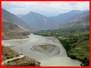
Kunar Valley is a valley in Afghanistan and Pakistan. In Afghanistan the length of the valley is almost entirely narrow with steep and rugged mountains on both sides. The center of the valley is occupied by the Kunar River flowing south where it joins the Kabul River. Subsistence farming and goat-herding are the extent of agriculture production on the valley floor and lower elevations. There are limited and small forested areas in some side valleys but the more than 95% of the valley has been deforested. In limited areas at higher elevations there are sustained grassy mountain meadows. Overwhelmingly though the Kunar Valley is an arid, rocky, steep landscape with a fast-moving muddy river as its primary geographic feature.
Kunar River
The Kunar River is about 480 km long, located in north-western Pakistan and eastern Afghanistan. The Kunar river system is fed from melting glaciers and snow of the Hindu Kush mountains.The river rises in the far north of Chitral District in Pakistan. Downstream as far as Mastuj it is known as the Yarkhun River. From there to its confluence with the Lutkho River just north of the important regional centre of Chitral it is called the Mastuj River.It is then called the Chitral River, before flowing south into the upper Kunar Valley in Afghanistan, where it is referred to as the Kunar River.
The Kunar River empties into the Kabul River just to the east of the city of Jalalabad in Afghanistan. The combined rivers then flow eastwards into Pakistan, joining the Indus River at the city of Attock


No comments:
Post a Comment